
Plotting
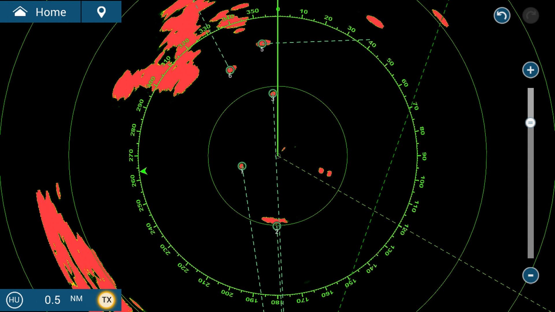
A busy scene to be navigating in reduced visibility. The target just ahead to starboard is a buoy and the entire starboard side of the screen is too shallow for us.
Have you ever been on a boat where the skipper plows through the fog looking down at the radar, then up to see if they can see the target boat visually, and back and forth until the boat appears, only to then make a frantic turn to avoid a collision?
Unfortunately, this seems to describe a high percentage of radar users in reduced-visibility conditions.
But it doesn’t have to be like this. Radar can give us the information to avoid tight situations in both good and bad visibility.
Just think about big ships plowing along at 20+ knots. If they waited until they had visual contact, they would be colliding constantly, but they successfully use their toolset, most importantly radar, to proactively mitigate the risk of collision while outside of visual range.
In this Chapter we will evaluate common radar-plotting techniques, and in Part 2 we will examine how to use those techniques to make course and speed changes to avoid collisions.
The Eyeball Technique
The technique described above is the eyeball technique, which is exactly what it sounds like: you watch the radar screen and mentally try to plot the trajectories of the different targets.
Pros
- No additional hardware required.
Cons
- Very hard to mentally plot another boat; the track line is almost always off.
- Humans are very poor at keeping track of a high number of targets.
- Requires frequent checking of the radar screen.
- Assumes both vessels are holding a constant course.
Example
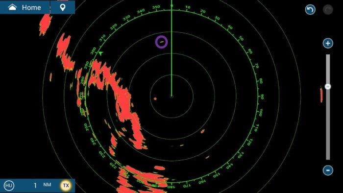
Let’s look at what this looks like in the real world. We pick up a new target on the port bow, which I have circled in purple. The target is obviously getting closer, and it seems like it could pass quite close.
Unfortunately, as our boat rides to the swells, our heading keeps changing, confusing what is going on. Other than knowing to be alert, we don’t know what to do.
Verdict
Coastal:
Does not give actionable information for close passes.
Offshore:
Does not give actionable information for safe passes.
In both cases we know to be worried about a target, but not how to change course.
Let’s look at better alternatives:
Hi Eric,
What a great subject and article – thanks.
From my distant past, radar certificate and 8 years as navigator on ships, I have a love / hate relationship with radar – let’s say, about “big ships plowing along at 20+ knots. If they waited until they had visual contact, they would be colliding constantly” is absolutely correct in theory, but so wrong on some scary occasions…!
Where we sail in NZ we almost never experience fog. But have a Raymarine radar for cruising to the SW Pacific Islands, where navigation marks can be few and far between, and where locals have a penchant for moving them to suit their own purposes.
So I haven’t a lot of recent radar experience (it’s almost always turned off), but from my time at sea I do like having Relative Motion (RM) AND True Motion (TM) for plotting in coastal waters and close confines. We always had two radars on our ships’ bridge. In coastal waters, I would have the one adjacent to the chartroom on North Up / TM, and the one on the bridge front on Course Up / RM. The first was primarily used for navigation and the second for target identification. For me, collision avoidance was done using inputs from both TM and RM, but other (often more senior) officers had other preferences.
On our yacht, with our Raymarine HD Radome we have two MFDs. One can be on TM and one on RM. In the very few instances we have experienced poor visibility, the nav station one we have on TM / North Up (also with chart plotter overlay) mirrored to a tablet in the cockpit under the dodger. And the helm station screen on RM / Course Up.
Raymarine MARPA works really well in TM mode, displaying a target vessel’s true course & speed over the ground within about 30 seconds. You see your and their vessel’s motion relative to the land, and fixed points like buoys and channels stay still, so are more easily identified.
AND we turn on the radar trail (wake) feature in TM, that gives a nice visual representation of a target vessel’s course and speed. Another benefit of TM mode (for Raymarine anyway) is it uses COG and SOG which comes from the GPS and is always accurate (praying that Mr Musk doesn’t turn it off, so he can charge for it).
Our helm station MFD using RM and MARPA, will show a target vessel’s course and speed relative to our own, so that is also very useful. But RM MARPA requires accurate heading (not an issue for us) and boat speed input (can be an issue for us if our paddle wheel speed sensor gets fouled). If this happens then our RM MARPA information will be suspect.
The downside of TM is that your boat’s position moves across the screen and every so often you have to reposition it (before it automatically repositions).
If I had to choose just one mode for poor vis in coastal waters, day or night, it would be TM.
And Eric, call me “old-fashioned”, but you can’t beat china graph pencil for plotting at night. Points (targets or landmarks) marked so, standout brilliantly and are easily wiped off with a cloth when passed. Ok yes, you may need a cleaner the next day, but no big deal.
A piece of tape just won’t be easily visible on a dark night without a torch IMO, and how do you draw a line with a piece of tape without hiding heaps of stuff at the same time? I can use a soft ruler and china graph pencil to plot relative courses of a target in RM mode, directly on our MFD screen.
In my time as navigator I never used a paper radar plotting sheet once, it was all done directly on the radar screen with chinagraph pencil & rule, plus an early CASIO digital wrist watch, set to beep every 6 minutes. But then we never had electronic charting and we only got a satellite navigation box on my last trip away in 1983!
Hi Rob,
Thanks for adding lots of good information. As I was writing this, I knew that I had at least 1 former navigator (you), who would be watching this.
Most of my experience is on vessels with 1 radar or with 2 radars but only running 1 most of the time so I don’t have a lot of experience with 2 different options at once (my experience was before configurable digital displays and if we had a repeater it would be in a different location). I definitely prefer heading up for collision avoidance despite strongly preferring north up for navigation. With our configurable display now, we will run a radar screen heading up, the chart north up and then toggle on and off the overlay as needed on the chart and this seems to work well.
I don’t think I have ever used a grease pencil on a cruising boat type radar display, only on much bigger commercial displays which also lay much flatter making it much easier. Have you tried it on your MFD and is it relatively vertically mounted as is common? I always used paper for plotting on cruising boat radars. I found that if there were only 1 or 2 targets, hand plotting course up was faster, easier and less error prone. But I also found that on the rare occasions there would be several targets at once, north up was easier for me to manage, especially if we had to make more than 1 course change during the plots but there was no way I could multitask and do anything else including keeping a lookout at those times. A few years ago, I finally recycled all my blank plotting sheets.
Interesting how your paddlewheel can hurt MARPA performance in course up, I would not have expected them to use that input. We run heading up normally just out of habit and as it is easier when making a lot of course changes and never see any issues. I am pretty sure you don’t need speed through the water for that and I am guilty of often having a fouled paddlewheel and have never seen any difference. Most of the boats I used ARPA on before our electronics upgrade a few years ago didn’t even have a speed through the water sensor linked to the unit.
Tape on the screen doesn’t work if you actually want to plot but if you just want to see an approximate CPA based on the range rings compared to a straight edge, it works fine in my experience which is why I refer to it as a light technique. One of the boats I was on spent a lot of time navigating foggy rivers with a lot of chart datum shift. We started carrying little dot stickers that we would put on the chartplotter screen to compensate for the shift but you had to be north up and you couldn’t change range. I did use them a bit on the radar and they worked fine but as ARPA took over, that kind of took away the need and I haven’t done it in ages.
Eric
Hi Eric,
Sorry for the delay in response – I was out on our boat and managed to pour 1/4 of a “long black” coffee on to my MacBook computer. Just got back on-line today.
No question course / head up relative (RM) is best for target identification and situational awareness. But collision avoidance in RM requires accurate plotting and in busy waters it’s easy to get this wrong, or be too occupied to plot with confidence, especially for the inexperienced.
It’s also really important to be able to relate what you detect on radar with what you see through your Mk 1 eyeballs as it appears from the fog/mist, and to 100% verify it using compass bearings. I used to have our two MFDs, digital displays and radar set to Magnetic North, to relate this to my magnetic hand bearing and steering compass. But then I found an App “Compass Eye”, a digital hand bearing compass for mobile which enables true north, so now we run everything on true north.
True Motion (TM), north up, gives you an almost instant appreciation of a target’s true course and speed without plotting. Having both is really the best of both worlds. In close confines in coastal waters, with multiple targets and numerous navigational marks to track, then TM really is good.
But then some people find north up the best way to envision the world (my wife). And others find head up the only way to relate to what they see. My brother is a NZ Coastguard skipper and a few year ago rescued the crew from a launch high and dry on a rock at night. Someone had changed the boat’s chart plotter from “head up” to “north up” and the skipper was so completely confused by this, he ran his vessel aground on the only rock for miles around.
I should have mentioned that I was talking about a white chinagraph pencil which works fine on our cockpit chart plotter, at night. Our MFD is angled at about 40 degree from vertical so it is practical to plot on the screen. But in practise, MARPA does this for me so we haven’t needed to plot on screen. Also I broke our old 6″ flexible plotting rule and can’t find a good substitute – anyone? Rather I use chinagraph to highlight dangerous targets and note the bearing and range of targets on screen.
WRT speed through the water in RM mode, this is what our Raymarine manual warns us. But since the speed and bearing MARPA gives in RM mode is relative to us, I’m not sure that this error, on reflection, would be material..? So you could be right, and I need to research this more -> anyone?
Hi Rob,
Sorry to hear about the computer problems.
Good point on using a compass to relate reality and the screen, I know that it helps me a lot as otherwise I will be looking for something 6 points off the bow while looking 3 points off. I generally just take the bearing off the bow from the radar and quickly add or subtract it from our heading and then look across the compass card but I can see a hand bearing compass being easier.
Thanks for the info on plotting on the screen of a cruising boat style chart plotter. Now that so many are touch screens, I wonder how that would impact that, I know some already have issues with rain and other contaminants. Some of the screens also have fancy coatings to make them easier to read which is a consideration.
John has written previously about chartplotter orientation and I know he is a big heading up fan (https://www.morganscloud.com/2019/08/27/12-electronic-navigation-tips-from-a-cruise-on-someone-elses-boat/). I know my preferences for my own use are a bit different but one thing that is clear is that getting it wrong can have really bad consequences.
Eric
Thanks – good article.
I would note that in fog there is no stand-on vessel in the Col Regs and the responsibilities for each vessel are defined in those Regs. (Noting that, even if one vessel can see and the other vessel and they can’t see the other, observing the Regs will avoid a collision).
I would recommend the RYA IRPCS book that has the regulations, interpretations and suggestions for yachts on what to do/avoid.
With respect to VHF I think it is sometimes good to call the other vessel in order to let them know you are there and that you are a sailing vessel (so probably stand-on). I would, however, be extremely reluctant to agree to alter course in any way other than prescribed in Col Regs.
Hi Clive,
I agree, COLREGS needs to be our guide here. Part 2 goes through what to do with the information from plotting to make course change decisions and a key component of it is COLREGS including the restricted visibility section. Thanks for the recommendation on the RYA book on this, I have not read that, I have simply read the regulation many times over.
Yes, I agree that the VHF can be good to use sometimes but given limited bandwidth, I prioritize plotting and following up with evasive action as I have found better success with this in the places I sail but I certainly use the VHF some too. Some of the VHF trade-off is undoubtedly the difference between coastal and offshore. Part 2 has some examples of this and it would be good to get yours and others thoughts on what you find works best in those situations.
Eric
Sorry – just re-read and note that there is a “part 2” coming so I jumped the gun by talking about Col Regs.
With respect to VHF, I don’t think it has much use for coastal sailing. Last week a colleague called another vessel and suggested we pass “green to green” – I bit my tongue but was relieved when the other vessel said “no, port to port”. Just follow Col Regs!
On the other hand, when crossing the English Chanel I have used VHF a couple of times. “XXX this is Sail Training Vessel ZZZ”. It is quite busy and even though the merchant vessels are out of the separation scheme there is a tendency for them to just plough on regardless of their obligations to crossing traffic. Whilst one will always try to avoid interfering with a “working vessel” you can’t wait all day to cross and when we do, we have obligations as stand-on vessel not to “second guess” the other vessels and just maintain course and speed. The call is merely a “wake up” to the other vessel.
It is if they fail to answer then things get a bit tricky – that does happen, but not to me (yet).
Another time, when motor sailing I called up a vessel to confirm that we were the give way vessel (no way he could see our inverted cone at distance although he might have guessed as we were doing 7 knots with not a lot of breeze). We then altered course to starboard. Everybody happy.
Hi Clive,
It sounds like our thoughts on the VHF are reasonably well aligned. As you point out, the goal is not to agree on something that is against COLREGS, it is simply to make sure both parties are aware and agree to what they should already be doing.
Eric
Good article Eric.
You lay out the challenges in an easy to understand method.
The challenges for most boater’s attempting to use radar, is the lack of experience with radar. It is a new to them sensor that they have difficulty understanding the graphical interface. It is like a toddler learning to talk. The best action for a boater with a radar is to use it when visibility is clear and 10 plus Nautical miles. Learn to decode the pretty blips with the actual boats, land masses, and objects around the boat.
Several years of radar responsibilities aboard USN aircraft using a grease pencil served to help me decode the blips and squiggles shown on the screen.
My boat came with an analog radar which is helpful identifying land masses but lacked the ability to pickup small fast moving objects. When the stealth fishing vessel (in the attached image) came out of the fog heading directly at my boat. I was saved by quick action and having my head out of the cockpit. The result was a glancing blow. Damage was minimized.
The introduction of ARPA on Furuno radar has me awaiting the delivery of a new system.
You can be sure, once installed there will be continual practice in clear weather building the skills interpreting the images and then verifying with the objects surrounding my boat.
Looking forward to your Part 2
Hi John,
You are absolutely right on the importance of practice, I know that radar was something I could just pick up with no instructions or practice and I think that is probably true of others as well. People who had to hand plot professionally like yourself and Rob have a huge advantage here compared to most recreational boaters who only turn the radar on when it is foggy or dark.
It looks like the end of your comment got cut off, I hope the story did not end badly.
Eric
Hi Eric and all,
And, on the subject of practice, I wrote this a while back:
Training exercise: radar
Hi all,
Radar is one of those maritime skills that really demand practice. Practice and drills for cruising boats are an important ingredient that keeps us safe: but they are often neglected, usually a bit of a pain to execute, take effort and none of us likes to think about the possibility of serious injury/death. So, taking action is easily put off for another day.
We found a way to get more skilled in radar navigation a bit of fun. This exercise is easiest if your radar display is down below and takes 2 people: one person at the display who calls out course changes and a running commentary on the display returns (large return at bearing 030 at 2 nm; intermittent return at 1/4nm at 220 deg bearing and closing the distance). The other crew is at the helm following course suggestions and ensuring boat safety and giving feedback on what the radar is revealing. (Intermittent return is a wooden small fishing boat.)
We did this often on the trip from Block Island into a favorite anchorage in Little Narraganset Bay near Watch Hill (the Kitchen, so named as the hurricane of ’38 swept dozens of shore side large summer homes into the anchorage and for decades cruisers would get their anchor caught on a kitchen sink or a true ice-box and the like)). This route usually gave us some traffic, both recreational and commercial, and a moderately tricky entrance into the anchorage where the radar was used for land masses, low lying islands and ATONS (buoys, day marker poles etc., various kinds of aids to navigation).
This can be quite amusing such when I was requested to come up to see a huge slab-sided freighter crossing our bow about 1/4 mile off which I had totally missed: taught me that I needed to regularly change the range. Also, that I really cared about the 4-6 nm range and would move from that range to check greater distance on a regular basis.
My best, Dick Stevenson, s/v Alchemy
Love the drill, Dick. I’ll be incorporating it in my on onboard experiences.
Hi Dick,
That sounds like a great exercise. I have done many similar exercises such as making the chartplotter only available to 1 crew member and then having others use dead reckoning to get through a tricky area but never what you suggest with radar.
The drill that we normally do is to have someone plot in good weather and talk through the right solution by looking around but it is definitely not as real as you suggest. This is probably a good step for newer users and then they can move up to what you suggest.
Eric
Yes. For some reason when I prepared the message I tried to copy and paste the photo. It injected a large string of garbage data in the message, no photo. I had to erase the errant data string and then repost.
The story ended with the boat water tight. The stern deck joint was damaged (knocked about an inch off alignment), I lost the stern pulpit. but all was repairable. The radar sensor failed to provide information. My caution and attention to the sounds and monitoring of the area was what saved me. Awareness and prompt action at the helm to try and evade the other boat. Had I not reacted the fishing boat would have T-boned my boat just behind the mast.
When I chat about the use of radar, my first question is when was the last time you turned it on? It is a great tool. You just can not leave it in the tool box and expect to be proficient at interpreting the signals it is giving you.
Yes the new systems are a huge improvement. The worst behavior you can allow is to become complacent and expect a tool to do all the work.
I like the two person practice routine that Dick shares.
Hi John,
Sorry to hear that there was indeed a collision and damage. Many boats out there do not follow the rules around safe speed, particularly at night and in the fog and I find this particularly terrifying for those of us on boats that don’t have the speed to take evasive action.
I will say that my experience with a newer radar (Furuno DRS2DNXT) shows that the capabilities of small boat radars really are improving. Most of the radars that were sized for a cruising boat that I used before really struggled to pick up small fiberglass center consoles zooming along and certainly couldn’t get an ARPA plot but our radar now picks these up at much greater ranges and can actually plot them. When we first got it, I was playing around with manual tuning sitting on the mooring and wondering why I was getting all these weird ARPA plots zooming around and finally realized that I was plotting birds circling and with pretty good accuracy too. Of course, one thing is that you still get better performance with manual tuning and in a few cases, the difference is dangerously large so you do need knowledge and practice still. It will be interesting to hear how you find it once you get your new system.
Eric
Another basic tool is echo trails, as they draw the relative track on the screen. Not a perfect tool, but it can in just a minute give you an Idea of wether a target MAY be dangerous. For example. Trails that are parallel to the boats track and the same length are stationery. Granted, using echo trails can make alot of clutter quickly. So it is another tool not THE tool.
Hi Carl,
I agree, echo trails can be a good initial screening tool to see if plotting is required. That being said, for ARPA users, it is good enough now that I don’t find them helpful as I just plot any target that may be of concern. Is there a particular situation that you recommend using them?
Eric
I have a radar plotting sheet with the expected actions written on it based on the arc that the intercept is coming from. It is great aide-mémoire and reduces the memory requirements for vessels not in sight of each other.
I tried to upload an image, but can’t see how to do that.
My plotting sheet aide-mémoire.
Hi Alastair,
I have seen something like that before and produced in quantity, maybe someone like Weems and Plath makes them? I understand the theory behind them but have admittedly never really tried to use one in anger as I tend to focus on plotting. For others, my understanding of reading these is that it helps you with the general action to take if a target is in a given sector with a constant bearing and closing range. If the bearing is not constant, then the action to take is not necessarily the one written there. The suggested course changes are necessarily quite large as you do not know the full vector of the other vessel, only that they are on a constant bearing which could be due to a wide range of aspect and speed.
My general goals are first to be safe and then second to keep course corrections manageable, lots of big course changes when sailing is not a lot of fun. On the safety front, things are pretty easy with a single target but when you start navigating in congested waters, especially with reduced visibility, going by very conservative and broad rules can be quite tricky as reacting to a target often puts you at risk of collision with a different one or having to start the engine, etc. With plotting, you can see how this will work out ahead of time. There is even an official term known as “trial maneuver” that is a required features for radars fitted on ships above a certain size so they can game out different scenarios before committing. Part 2 will go into this a little more but doesn’t go into detail on multi-target situations which would really be a different article. It would be interesting to use your plotting sheet in the examples given and compare to the recommendations from the methods I chose for the situations.
Eric
Hi Eric! Great subject.
I think I had forgotten how good we have it on our vessel. It’s an oldy (1977), but a load of tech had been thrown at it.
Our B&G radar interface is amazing. I cannot compare it to other brands. You have probably heard everything about those systems already. It has a few very useful features.
We don’t have the latest, so I can’t imagine that. But it lets us set up a safe bubble around our vessel as well as safe guard zones. If anything threat worthy enters the zone, you can be warned if you set it up that way.
If there are vessels on AIS, we have the closest point of approach(CPA) and the time to the closest point of approach (TCPA). So I can know if both ship maintain course as is, in 8min34s, I’ll be 12.4 miles from the other vessel and it’s the closest we will come to each other. It keeps adjusting the data in real time. But, my favorite feature is definitely the ability of the radars to acquire targets. It can do so on it’s own, and suggest them to you as they enter the safe guard zones you have set up around your vessel, but you can also select a target. If you suspect a blob on radar to be a ship without AIS, you can click “acquire target”, and you will get the CPA and TCPA with the object. Could be a rock and you see the speed is zero. Still you know how close you will pass by it if you maintain course. And it will keep tracking it for you. Sometimes it’s a small vessel and it’s moving fast.
It’s also proven itself for tracking squalls as well. You can track the storms with the “Acquire target” function. You can know which cells are moving fast and in what direction. In squall territory last season, we were going to a new anchorage and efficiently tracking 4-5 storms cells at a time. Sometimes, the storm cell dissolves and you get the message “target lost”, but some other time, it’s really onto you and the clock is ticking for you to get ready to take it if you cannot alter course enough. You know it’s coming at a speed of 24 knots and will be on you in 5 minutes. How insane is that? In daylight when you have other cues, it’s an added benefit, but at night, it’s a blessing with nearly no disguise if used wisely.
That brings me to the downside of technology. How badly some people set up their fancy tools can be the best way to self sabotage and become a liability on the water. Knowing what the tools can and can’t do and how to use them is a must. Relying solely on the radar alarm system or thinking whales show up on radar because they are so big comes mainly from genuine ignorance… I’ve heard both those things by the way.
Anyhow, reading your article made me feel very spoiled. I’m interested in your take on safe practice for altering course.
Hi Marie,
I am generally a person who likes to keep it simple and limit tech but radar is one place where I really appreciate it. With where we sail, having it is a no-brainer and it is definitely a case where some systems are better than others. I am a few years out of date on using the latest from all the brands but whenever I am on a boat with an older or less desirable unit, I really feel it.
That is very interesting on tracking storm cells with MARPA. I will have to try that, I had still been hand plotting them. I know that our unit will pick up the edge of a cell as several ARPA targets so I usually just turn off automatic acquisition but maybe I could get it to acquire the whole cell.I don’t remember doing it with any of the larger commercial units I have used either. Any tips on how you do it would be appreciated.
You make a good point that with all these fancy tools, we have to learn to use them properly. In fact, what pushed me to write these 2 articles was observing scary situations in reduced visibility on boats kitted out with 10’s of thousands of dollars of electronics plus 2 specific conversations. The first was with the owner of the largest Furuno dealer near us who was trying to save me money as we were updating our electronics and trying to get us a low accuracy 4 DOF compass instead of the 6 DOF satellite compass. His reasoning was that it would probably be good enough for chart overlay, he didn’t even realize that I would want the ARPA functionality to be as good as possible. The second was a conversation with a 30 year full time vessel master who did every summer in Maine and held a radar observers unlimited license (last I did this it was still hand plotting) and didn’t know what ARPA was and admitted to never having done a hand plot outside of the simulator as most of his work is coastal. So my goal become to simply make people aware of techniques that can be used and then some practical tips on how to implement them in the hope of moving the needle slightly on collision avoidance.
Eric
Hi Eric, indeed, radar, in my opinion, when it comes down to tech, is a very good place one should put their money. That and AIS perhaps if a sailor hasn’t gone that way yet. We should all try budging that needle slightly on collision avoidance! I think we are all on the same page here when it comes down to that. If radar is used properly, it can really make a difference. I therefore commend you for this article. Hand plotting is for many the only way.
I think that many retailers themselves don’t even know the full length their products can go to and what features make a product attractive to sailors. It could be especially dependent on what weekend adventure makes them tick: are they more into cloth or more attracted to catching bass at the delta entrance? And when people purchase equipment, if they don’t go through the effort of knowing the tools they just bought, most of it remains useless. Same goes with cars when you think about it. When they sell you the car and go for a little stroll, you will not, these days anyways, know the full potential of the cruise control features…
For reference, we have a multifunctional display of the B&G Vulcan series and it’s most likely already 4-5 years into use and it was not the cream of the crop at the time of purchase by the previous owners of our boat. I don’t know what they make right now, but it must be radical. I believe our radar range is 24 miles.
I have an undergrad in geography where I’ve learned a fair bit about radar and imagery and image acquisition with technology using various frequencies. Tracking storms was definitely one thing I wanted to try once I started looking into our radar interface. It can and does so very well.
In terms of how to go about tracking storm cells with MARPA, what I can mention goes for B&G but perhaps for other brands as well, I have no idea.
First, if we are in squall weather or stormy weather and we want our secondary set of eyes to be at it’s best for that, we change the radar mode to Weather Mode. It will not stop warning us for other potential types of targets, but it will be optimized for the weather. If there is a storm cell around, it will show on the monitor. We click on it for one or 2 seconds and “acquire target” appears in the right column on the screen. I always try to click in the thick of it. It takes a couple seconds and it confirms the acquisition of the target which the system then tracks like a ship on AIS. You then get it’s SOG speed, CPA and TCPA. You have the summary on the right side of the monitor. I don’t know how many it can track simultaneously because we’ve never maxed it. It shows the closest to you first on the right and you can drag down to see all your other targets. Sometimes vessels are in there too (in your targets), depending of where you are at. It’s honestly amazing.
When one reads the manual, to my dismay, it’s not like B&G tells you you can track storm cells. The whole Vulcan series manual is written in a “how to” fashion in order to learn how to use the interface. But it does show how to acquire target without telling you what a target can be aside from being something on the screen. Their exact wording is “Any radar target within a preset range can be acquired and tracked”. If you ask me, it can be whatever you actually see with your eyes on the monitor. Some storms dissolve as they die and you get the message “target lost”. Sometimes if you did not put the tracker in the thick of it, you need to reacquire it, but it’s not a frequent occurrence on here. On the B&G website, you can read testimonials of sailors that are along the lines of “now I know the squall is X miles away and is coming for me” type of testimony. That’s exactly what I’m describing. I think it would be good for them to be more explicit with that feature because it’s just fantastic.
We’ve successfully tracked several storms cells simultaneously that way when we were in the ITCZ last year during our Pacific crossing where it’s definitely squall territory, as well as in FP, Tonga and Fiji where the weather seemed more prone to be under that stormy kind of weather on some days (a friend had a microburst of 99 knots in Fiji on one of those days and that made us even more prone to using radar in daytime while under way, providing the atmospheric pressure cued us).
It’s also interesting to look on radar what different types of storms around you or coming you way during daytime actually look like on radar. You can train your eye. A storm at different stages will not look the same. Think of it as learning the shapes of clouds and what they mean. That way, at night, you may recognize patterns. I saw what a gigantic waterspouts looks like on radar (Tahiti). I should have taken a picture. Anyhow, I could not possibly count the times acquiring storms as targets has come in handy. We dodged countless squalls that way and have been hit by many that we saw coming, thanks to our extra set of eyes acquiring targets.
About using radar properly, it’s the duty of the person that starts using the radar to verify the settings on SEAMER. For example, I know that I used the radar last on a calm sea and had therefore adjusted the sea state to calm seas. It makes the radar super sensitive. It probably won’t be adequate for the next night shift. We came into a marina in daytime. If we leave at night, we will probably want to put it in “Harbor mode” for best target discrimination, fast refresh rate and precise detection of traffic. Once in the open sea, we will switch it to “Offshore mode” and adjust to the current sea state.
I hope your system allows for you to try some storm tracking by target acquisition! [Sounds a little too much like “Twister” the movie when I write this.] More seriously, I would have trouble hand plotting an incoming storm. There is always other things to do even when I’m spoonfed the CPA and TCPA by my system, like reefing and/or bringing a whole sail down altogether. Right?
Hi Marie,
Thank you for the great information on plotting storm cells with MARPA. I will definitely give it a shot next time we have them here. Some years we get a lot and some years very few. I definitely wouldn’t mind not having to try to hand plot them, as you say lightening the load would be nice as it tends to be a busy time.
And I agree that many of the sellers of fancy electronics are not knowledgeable about them or they assume our interest is something that it is not. When seeing if there were any real reviews online for our unit before purchase, most of the hits were related to bird mode which I guess fisherman really like for helping to spot fish.
Eric
Hi Marie,
Hadn’t occurred to me either, that we could plot intense rain cells using MARPA. As Eric says, must try this.
I have used radar for predicting wind shifts at night offshore. Most of the time offshore we have the radar on standby to save power. But if there are downpours around we will turn the radar on. Big clouds with heavy rain coming from them also have wind radiating outwards in all directions. This local wind adds to or competes with the gradient wind and the resultant wind will be the summation of the two in strength and direction.
So we use the radar to predict knocks or lifts, lulls or squalls. It depends on which side of you it will pass and where the gradient wind is coming from.
And MARPA plotting will assist if it works on our set. Many times we have altered course to have a squall arrive on the optimum side.
Setting off for the Bay of Islands next week with a big front coming through behind us, so I may get some practise in!
Hi Rob! Nice to read you again! See the tips above in my reply to Eric. I hope you are successful at tracking storms on MARPA (or not in fact, that’s me wishing you the best weather!).
Sounds like a smart use of radar for predicting wind shifts. We leave it open all night, but we have massive battery power, a luxury many sailors don’t have. The oven and stovetop are electric, who does that?! A family of 6 liveaboards of course.
We are in Nelson at the moment, we came in from Milford Sound right before Thursday’s forecasted little mayhem. We will go to the Bay of Islands in the coming two weeks, completing our circumnavigation of the whole NZ Coast. Your country is beautiful!
How long will you be in the Bay of Islands?
Marie
Hi Marie,
First MARPA localised heavy shower cloud plotted, AND avoided by pinching up to windward above our route (see pic) PLUS we stayed dry. Plotted in relative motion, north up with overlay. NE 15 knots forward of the beam, Code 0 and one reef.
First remembered to plot the shower at about 15 nm. Impressed because we were heeled at about 20 degrees and our radar isn’t gimballed. Its real path was more right to left than the photo I took. Each time I changed screen scale, the plot became rather random for a few minutes until it settled again. Not sure why this was.
Just arrived in the Bay and will be here until around the 15th April (weather dependent) after which we have to make our way slowly south and homeward.
Br. Rob
Hi Rob,
Fascinating! Thanks for the real world fill on that.
Thanks John, a pic of the actual rain squall taken about the same time for scale context.
Hi Rob,
Thanks for the shot, useful to see the squall you were tracking to match the radar image. I will definitely be trying this out this summer.
Hi Rob,
This is great to see. I am looking forward to trying it out soon with our set.
Eric
Hi Rob! that’s just great! We are on our way to Opua at the moment. We officially left the 40s behind. Let me know if you are still around 🙂 https://forecast.predictwind.com/tracking/display/SV-Seamer/
Hi Marie,
Nasty tropical low approaching by Wednesday, AND moderate south easterlies with 2 metre seas ahead of it. I’m sure you know this -> Whanagaroa Harbour will give you great shelter if you can get in before the low.
If you get into the Bay ahead of the gales, we will be here until Friday 18th and leave after the low has gone through. I’ll keep an eye on your track.
Hi Marie, you made it just ahead of the blow, bravo. We are in BOI Marina, on F21. SV Bonnie Lass until Saturday am.